After admiring the impressive bluffs in Montaña de Oro State Park, my curiosity took me to private lands possessing serious hazards such as sinkholes, snakes, electric fencing, poison oak and crumbling earth.
****
Once we finished hiking one of the loops of the Bluff Trail, we drove the car to the end of Pecho Valley Road (main road on the park). We were trying to find the trailhead for a short hike but hit a dead end instead.
Before turning back to Morro Bay, I saw people passing thru a small aperture on a gate topped with barb wire.
“Let’s see where they are going,” I said. My husband gave me an “I don’t think that is a good idea” look but ended up surrounding to my desires.
A few meters after passing the gate a sign warned, “You are now leaving state park property and entering private property. Permission required for entry.”

Sign at the beginning of Point Buchon Trail
“We better go back. I don’t want to get into trouble,” my husband whispered.
As a defeated look started to cover my face, my eyes caught a glimpse of a small wooden structure.
“Look up there. I think that is where they give the permits to hike the trail.” This time my husband gave me an “I hope there are no snipers around here” look.
We crossed the bridge over the Coon Creek and ascended a small hill. A ranger greeted us with a smile and gave us the green light to walk around the property. However, there was a caveat. We had to sign a document releasing the owners of responsibility for any injuries acquired inside the property. I deducted I was able to deal with lighting, wildlife and steep cliffs (among others).
Later, I discovered the trail and adjacent property is owned by the Pacific Gas and Electric Company. They use the area as a buffer zone for their Diablo Canyon Nuclear Plant (does that qualifies as another hazard?). The company opened the Point Buchon Trail to the public in 2007.
The entire trail has a 6.25 miles round trip length. There is a 1 1/3 mile loop for those who are looking for something shorter. We chose the small loop since it was dark, cold and windy. The fog was already descending from the mountains.
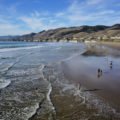
The first point of interest was the Coon Creek Beach (only beach access on the trail). We descend thru sandy stairs to explore sea caves.

Sea cave in Coon Creek Beach

Exploring a sea cave in Coon Creek Beach
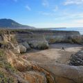
Back on the trail, we witnessed the water roaring below a sinkhole. I have to admit I was surprised to see such a big hole close to the trail (there is a fence protecting visitors from a drop).

Sinkhole
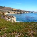
As we continued walking, rock arches, stacks and pillars started to appear close to the shore. Hundreds of cormorants and oystercatchers were resting over the statuesque piles dotting the coast. Layers and layers of burnt orange, tan and yellow rock were exposed on the cliffs’ faces.

Sea Stacks

Colorful layers of rock
After a day of discovering mesmerizing coves and sculpture-like rocks, I wasn’t expecting to see what I saw from the Point Buchon Overlook. It was a spectacle of wildlife, sea, rocks and wildflowers very different from what I already saw that day. I only can describe the view as a mix of sea caves, stacks and promontories to the 10th power. I even took a sequence of photos to convert it later to a panoramic. All the assumption of hazards and hardships paid off.

Point Buchon Panoramic
When I was researching this article, I found buchon means goiter in Spanish. Well, the problem is that I had never heard the words buchon or goiter before. Both languages failed me at the same time. Turns out goiter is a swelling of the thyroid gland (I know this as bocio in Spanish). When the Spaniards arrived to the area they met a Chumash chief with a huge goiter. They used to call him El Buchon. The land and the trail got their names from the chief. This is probably the coolest story I have read about naming origins. Only a place this beautiful can have such an interesting background story.

Sea stack closeup
After admiring the view for several minutes, we decided to go back to the trail check-in station. I was careful enough to avoid the electric fence and the holes in the ground (who knows what lives there).

Sea Arch
The rest of the trail, and the bobcats and the poisonous plants and the dangerous terrain, will have to wait till next time.
Have you hiked a hazardous trail? Let me know in the comments section below.
Note: Take a better look of the panoramic photo in my Facebook fanpage.

Becca@Electricians In Sydney says
This place must be protected or may apply a very restricted rules, so that no one will get hurt if ever someone will try to go there without permission…. a sign has more to say.
Lisa says
Love that place!! If you hike to the southern end of the Point Buchon trail you can see the Diablo Canyon Nuclear Power Plant. There is a sign that says something like if you keep going you could get shot (so your husband was on the right track with his sniper comment). Also, you’ll have to hike the Hazard Canyon trail next (also in Montana de Oro State Park).