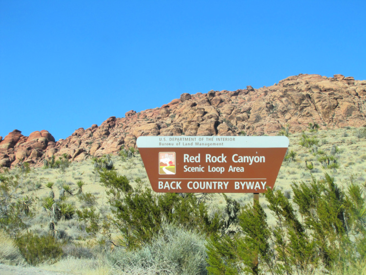
This detailed guide provides all the information you need to plan a trip to Red Rock Canyon National Conservation Area in Nevada.
Do you know there is a National Recreational Area 15 miles from Las Vegas Strip? Yes, you can hike and be surrounded by nature after a 45-minute drive from this gambling mecca.
I am referring to the Red Rock Canyon National Recreational Area. I have wanted to visit this place forever. During my last visit to Sin City, my wish came true. I thought this was a desolated area in the middle of nowhere but all the conditions are set to make this a wonderful day trip.
The road is in excellent condition, the visitor’s center is superb and the scenery is striking. Actually, the area receives 1 million visitors a year. Not as many as Las Vegas receive but a considerable amount enjoy one hell of a desert adventure!
This article will give you all the tools needed to plan the perfect trip to Red Rock Canyon.

Table of Contents
How to Visit Red Rock Canyon
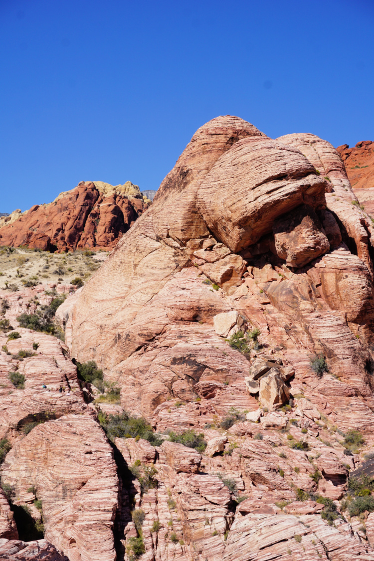
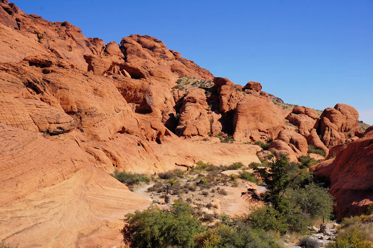
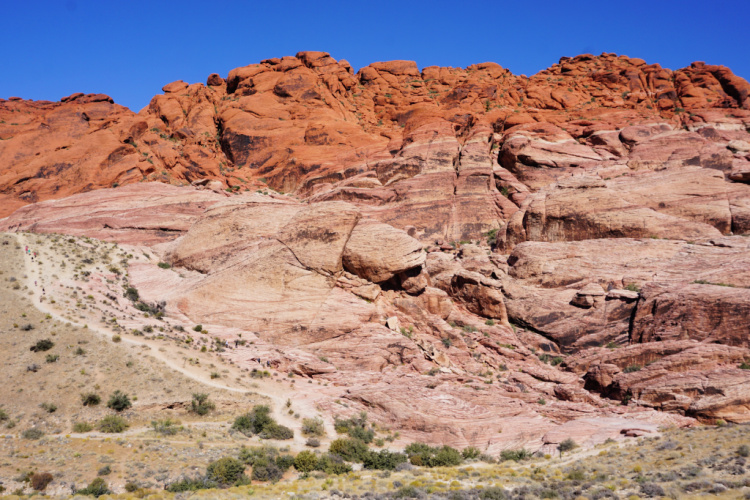
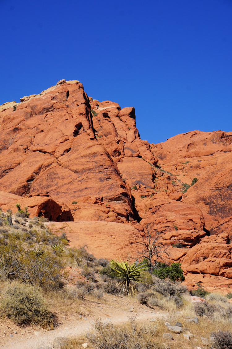
The conservation area showcases a set of large red rock formations (there are also white or cream-colored rock formations), mountains, canyons, petroglyphs, and streams. In short, this area will give you a glimpse of the West without having to go to Arizona or Utah.
As mentioned, Red Rock Canyon is located 15 miles from The Strip. The area is better accessible by car or paid tour.
The entrance fee is $15. Since this is a National Area, entrance is covered with America the Beautiful pass ($80 annually).
A one way, 13-mile scenic road provides access to many of the features in the area. Throughout the loop, you will observe signs pointing to different scenic overlooks. At each, overlook there are plenty of opportunities to snap pictures or walk closer to the rocks. What is more, the trailheads for different hikes are located in the vicinity of the overlooks/parking lots.
All the information needed to navigate the area and specific details about the hikes is contained in the Visitor Guide provided upon paying the entrance fee. Do not miss the guide since there is no cell phone service in Red Rock Canyon.
The beauty of this place is that you can walk/hike as much as you want. If you do not want to walk at all (or don’t have a lot of time), you can just drive the road and stop at the visitor’s center to get a good understanding of the geological formations and wildlife you can encounter.

When to Visit
Deciding to visit a place is highly personal. However, I want to give you some advice based on my experience.
Overall, I would say it is better to visit Red Rock Canyon when the temperature is under 90 degrees Fahrenheit. Based on weather averages, that corresponds to the months of October to May. Visiting during this time will allow you to enjoy everything the area has to offer without having to worry about excess heat.
If you are in the area during the summer months, you can do the scenic drive and get out of the car occasionally for photos. Another idea is to stop by as earlier as possible to avoid being in the area during the hottest part of the day.
I do not recommend hiking when the temperature is over 100 degrees Fahrenheit (this is serious).
How to Prepare
This is one of the most important sections of the article. Please pay attention.
You need to bring enough water for each person in your party. I recommend bringing a small cooler with beverages. Fill it with ice before heading to the park. The visitors center is the only place with potable water.
Come to the area with a full belly or bring lunch/snacks.
Wear the proper footwear if you are expecting to go beyond the parking lots. In all honesty, you should be ready to walk the trails or over the rocks. Even if your walking is minimal, you will need non-slippery, sturdy shoes.
Ladies, I do not recommend visiting in long dresses or skirts. Darker colors will work better.
Wear sun-protective gear (hats, caps, sunglasses) and sunblock. Combat the dry weather with body lotion, moisturizer (face), and lip balm.
Do not rely on having cellphone service.
Follow all establish rules.
Touring Red Rock Canyon
This section will give you a good understanding of what to see/expect at each overlook in the 13-mile scenic loop. I will provide information on what hikes can be performed from each overlook.

Visitor Center
Your first stop at the National Area should be the Visitor Center, a world-class facility showcasing the flora and fauna of the Mojave Desert. In addition, you will be able to direct your questions to the knowledgeable rangers.
Do not forget this is the only place to get potable water in the area.
The following trails can be accessed from the Visitor Center
- Moenkopi Loop (easy, 2 miles)
- Calico Hills (moderate, 2 to 6 miles depending on where the hike is started and how much you want to walk, less walking is required if accessed from the scenic road overlooks)
- Grand Circle Loop (difficult, 11.3 miles)
Important: The scenic drive will not return you to the visitor center. You need to visit before starting the drive.
Note: The Southern Nevada Conservancy is a non-profit partner of the Red Rock Canyon and Spring Mountains NCAs. Support this non-profit by buying something from the visitor center’s gift shop, their online store, or by becoming a member ($35 is the minimum gift amount).
Calico 1
This is where the fun begins (first overlook of the scenic drive)! The first stop of this drive will place you face to face with the red rocks.
You can take pictures from the parking lot and/or get closer to the rocks. Be careful since the path leading to the rocks has a bit of an incline. Once by the rocks, you can get as deep as you want into them. Some people climb high!
This the place to access the Calico Hills Trail (I think it is better to start it here than in the visitor center). From here, you can walk to the second and third overlooks in the scenic loop.
Calico 2
This second overlook provides a good glimpse of the red rocks too. I would say the trail to get closer to the rocks is safer than the one at Calico 1. Again, you can walk around as much as you want.
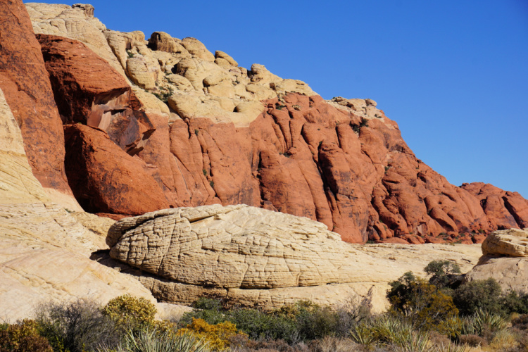
Sandstone Quarry
This overlook is different since you observe a mix of red, yellow, and cream rocks. The color combination is beautiful. Also, there are views of other features in the park.
Once again, you can start the Calico Hills Trail from here. The difficult, 5-mile Turtlehead Peak Trail can be accessed from the parking lot. It is a tough hike but the views from the top are incredible.
High Point Overview
At 4,771 feet, this is the highest point in the scenic drive. From here, you will have a 360-degree view of the National Area and beyond. You will not believe how small the Calico Hills (red rocks) look form here).
The overview has interpretative signs explaining how the geographical features in the area were formed.

Lost Creek and Willow Spring
To reach the Lost Creek parking lot and the Willow Spring Picnic Area, you need to get out of the scenic loop and drive a bit (less than a mile). These areas are located between canyon walls and offer views very different from the loop.
The other nice thing is that the trailheads for several easy hikes are located here:
- Lost Creek – Children’s Discovery (0.75 miles)
- Petroglyph Wall (0.15 miles)
- Willow Spring Look (1.5 miles)
If you are an experienced hiker, you can opt for the following trails:
- White Rock – Willow Spring (moderate, 4.4 miles)
- La Madre Spring (moderate, 3.3 miles)
- White Rock – La Madre Spring Loop (difficult, 6 miles)
- North Peak (difficult, 10 miles)
- Bridge Mountain (difficult, 14 miles)

Ice Box Canyon
More than an overlook, the Ice Box Canyon can be accessed through a simple dirt parking lot. From here, a difficult, 2.6 miles trail takes you to the depths of the canyon.
Red Rock Wash Overlook
This is yet another overlook that put you directly across the red rocks.
Pine Creek Canyon
Pine Creek Canyon is one of the most unique parts of the park. The moderate, 3 miles trail takes you through an open desert and a meadow.
The following trails can also be started from here:
- Fire Ecology (easy, 0.75 miles)
- Dale’s (moderate, 4.4 miles – This trail connects the Pine Creek and Ice Box. You can continue to Lost Creek
After Pine Creek, you can continue and exit the scenic loop or drive to the North Oak Creek parking lot/area.

North Oak Creek
As mentioned, the deviation to North Oak Creek can be found after passing Pine Creek. From here, you can start an easy, 2 miles trail.
Outside Red Rock Canyon
Outside the boundaries of the National Recreational Area, you will find the following:
- Red Rock Overlook – This overlook on highway 159 allows people driving by to get a look at the red rocks and the entire protected area. No entrance fee is charged.
- Red Spring/Calico Basin – Before reaching the entrance of the National Recreational Area, you will see signs pointing to the Red Spring area. From the road, you will be able to see the “other” side of the Calico Basin (the side of the red rocks you cannot see from the park). In addition, you can hike the easy Kraft Boulders Trail (1.5 miles) and Red Spring Boardwalk (0.5 miles).
- Middle Oak Creek Parking
- South Oak Creek
- First Oak Creek Canyon
- Spring Mountain Ranch State Park – This state park adjacent to the National Recreation Area has a historic ranch, hiking trails, picnic sites, grills, and other amenities.

Camping in Red Rock Canyon
The National Recreation Area is equipped with 53 individual campsites fitting 10 people and 2 vehicles each. Rates go from $10 to $60 ($20 is the price for individual sites). Reservations can be made using the Recreation.gov website.
The campground is open September to May. Keep in mind this is a very popular campsite.
If you do not find a spot here, there are several campsites/RV Parks on Highway 582 between Las Vegas and Henderson (including Las Vegas KOA, Thousand Trails Las Vegas RV Resort, and Las Vegas RV Resort.

More of Las Vegas
Things to Do in Las Vegas Other Than Gamble
Las Vegas to Death Valley Day Trip
Have you been to Red Rock Canyon near Las Vegas?
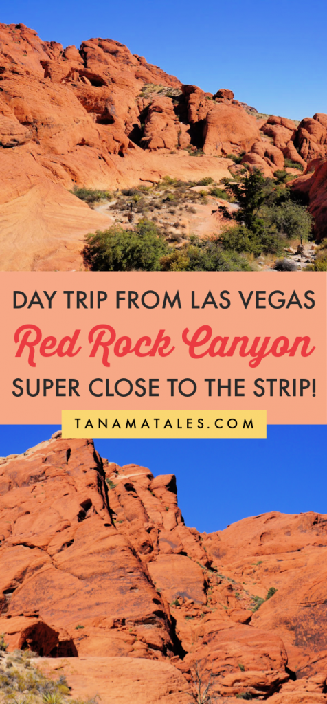
Pin “Red Rock Canyon” for later!


glen says
Beautiful pictures Ruth. Reading this post reminded me that I rode through Red Rock Canyon on a motorcycle last year, as part of a longer trip, and still haven’t done a post about it!
Ruth says
Uhhhh, great way to visit. What other places do you visited on that longer trip? Would like to discover interesting spots in the area.
Michael Figueiredo says
I’ve heard of Red Rock Canyon before but haven’t been there yet. It looks like a great place to detour after a day of gambling in Sin City!
Ruth says
It is a great place to detour. Lately, I have been hearing of a lot of cool places to visit around Vegas. Have to make plans to visit them all.
Cathy Sweeney says
I went Red Rock Canyon last June. It’s a great getaway from the Strip. Loved the hiking and beauty of the area.
Ruth says
Great Cathy!!!! See that you are an adventure gal like me.
Scott - Quirky Travel Guy says
Tortoise crossing! I love strange animal crossing signs and I’ve never seen that one. Nice pics.
Ruth says
Scott,
It the first time I see a tortoise crossing sign. I really wanted to see one during my visit but wasn’t able to. I also saw a lot of different animal crossing signs when I went to the Grand Canyon. I tried to photograph but the bus was moving too fast.
Emme Rogers says
Beautiful! Much more my style of a a Las Vegas trip.
Ruth says
I hear you Emme. I am trying to discover all the amazing things you can do using Vegas as a base.
Paula (Americana the Beautiful) says
I love road signs, too! love the irony/cuteness of the tortoise!
And thanks for adding destinations to my upcoming travels!
Ruth says
I know, the tortoise sign is pure cuteness. Not sure if I am going to kind something cuter (maybe a pinguin one). my pleasure to cause an overload on the places you want to visit.
Josh @ Green Global Travel says
Looks like a great place to visit for those in the Las Vegas area. Nice photos of this fantastic scenery!