Looking for the best Avila Beach hikes? We have you covered! Keep reading to find out where to get active in this beautiful beach town.
Nestled on the central coast of California, Avila Beach is a quaint seaside town known for its stunning vistas, mild weather, and diverse outdoor activities.
Among its many attractions, hiking stands out as a popular and rewarding way to experience the natural beauty of the area.
Whether you’re a seasoned trekker or just starting out, Avila Beach has something for everyone. In this article, we’ll explore the best hiking trails in Avila Beach, provide tips for preparing for a hike, and highlight other outdoor activities available in this picturesque coastal town.
Please note: This article contains affiliate links, meaning I may earn a commission if you make a purchase by clicking a link. Of course, this comes at no extra cost to you and helps me to keep offering solid information to readers.

Table of Contents
Avila Beach Hikes
Let’s get down to business. Here is a list of Avila Beach hiking trails you need to check out.
All of these are located pretty close to the city’s center. These are great options for those staying in Pismo Beach, Morro Bay, San Luis Obispo, and other cities in the area.
Shell Beach Bluff Trail
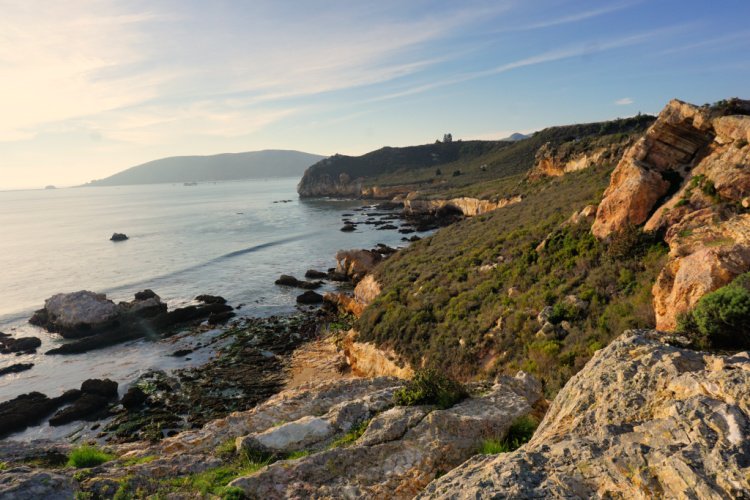
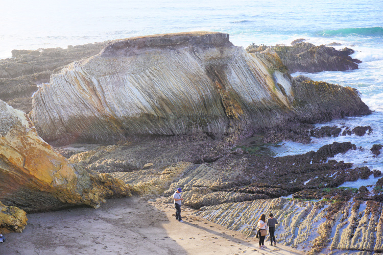
The Shell Beach Bluff Trail is a short and easy hike that offers stunning views of the rock formations, coves, and other ocean features between Pismo Beach and Avila Beach. The trail is just under a mile long and takes hikers through a residential area and along a bluff that overlooks the ocean.
The trailhead is located at the end of Cave Landing Road. The parking lot is labeled as “Pirate’s Cove Beach Parking” in Google.
Note: There trail can be accessed from Pismo Beach as well. The trailhead is located close to the intersection of El Portal and Indio Drives in the Shell Beach Neighborhood. The parking lot is labeled as “Cave Landing Trail Parking” in Google.


Ontario Ridge Trail
The Ontario Ridge Trail is a scenic 4.5-mile hike that offers stunning views of Avila Beach and the surrounding area.
The trail is rated as moderate to difficult, with some steep inclines and rocky terrain. Hikers should come prepared with sturdy footwear.
The trailhead is located at the end of Cave Landing Road. The parking lot is labeled as “Pirate’s Cove Beach Parking” in Google (same as for Shell Beach Bluff Trail).
The trail winds through coastal sage scrub and chaparral, providing hikers with plenty of opportunities to take in the flora and fauna (including hawks and falcons) of the area. There are several benches and lookout points along the trail where hikers can pause to rest and enjoy the views.
At the end of the trail, hikers are rewarded with stunning panoramic views of San Luis Obispo Bay. The view is especially breathtaking during sunset, making the Ontario Ridge Trail a popular spot for photographers and nature enthusiasts.
Note: There trail can be accessed from Pismo Beach as well. The trailhead is located close to the intersection of El Portal and Indio Drives in the Shell Beach Neighborhood. The parking lot is labeled as “Cave Landing Trail Parking” in Google.
There is another trailhead close to the intersection of Shell Beach Road and Avila Beach Boulevard.


Avila Ridge Trail
The Shell Beach Bluff and Ontario Ridge trails can be hiked as a loop. The combination of these two trails is usually known as the Avila Ridge Trail.
The loop has a 2.5 miles length and it is considered of moderate difficulty. Combining these two trails will convince you this is one of the most unique Avila Beach hikes.
Sycamore Crest Trail
Sycamore Crest is a 1.5 miles trail with an elevation gain of 498 feet (you will be climbing a hill) and is considered moderate in difficulty.
The trailhead can be found behind the Sycamore Springs Resort. At the top of the hill, you can enjoy spectacular views of the northernmost section of the San Luis Obispo Bay and Avila Valley. Dogs are welcome but must be kept on a leash.
From this trail, you can connect to the Ontario Ridge and Bob Jones Trails.
Pirates Cove via Cave Landing
If you want to hike all the way down to Pirate’s Cove or get a closer look at the formations in the area (including Smuggler’s Cave), you can take a partially-paved, 2-mile trail. This is a relatively easy hike but keep in mind there will be a 252 feet elevation gain on the way back.


Bob Jones Trail
The Bob Jones Trail is a 3-mile (one way), well-paved, mostly flat path connecting Downtown Avila Beach to the area behind the Avila Valley Barn. The trail goes through oak woodlands and along the San Luis Obispo Creek.
You will find the trailhead (and parking lot) on Ontario Road (after passing the KOA Campground). The trail ends close to the main pier. Or, you can park in town and start walking in that direction. As an alternative, the path can be completed by bike.
The trail is suitable for hikers of all ages and skill levels, with a gentle incline that gradually leads to the beach. Although the trail is well maintained and easy to follow, it can be quite busy, so be prepared to share the path with cyclists, dog walkers, and other hikers.
Along the way, hikers have the opportunity to spot a variety of wildlife, including rabbits, quails, and lizards. The creek that runs alongside the trail provides a refreshing respite on a hot day, and there are several benches and rest areas where hikers can pause to take in the scenery.
At the end of the trail, hikers are rewarded with stunning views of the Pacific Ocean and the Avila Beach pier. The beach is a great spot to relax and soak up the sun after the hike, and there are plenty of restaurants and shops nearby.
Note: The Bob Jones Trail’s official name is the Bob Jones City to the Sea Trail It is also known as the Bob Jones Pathway).


Pecho Coast Trail – Avila Beach Hikes
The Pecho Coast Trail is a historic 1.5-mile hike that offers stunning views of the Pacific Ocean and a glimpse into California’s rich maritime history. The trailhead is located at the end of Avila Beach Drive, and hikers can park at the Port San Luis Pier parking lot.
The trail is rated as easy, with a well-maintained path that winds through coastal shrub and grassland. Along the way, hikers can spot a variety of wildlife, including seals and sea lions.
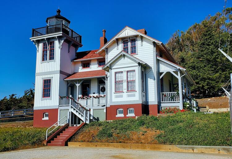
One of the highlights of the trail is the historic lighthouse. The lighthouse was built in 1890 and has since been restored to its original glory. Visitors can take a guided tour of the lighthouse and learn about its history and importance to the local maritime community.
Important: This hike can only be completed on a guided tour (takes place Wednesdays and Saturdays at 9:00 a.m.)


Hiking Near Avila Beach: Pismo Beach
Even though we have discussed a variety of fantastic Avila Beach hikes, I want to add to the article options in Pismo Beach since the towns are adjacent. If staying in Avila, you will have to drive less than 10 miles to arrive at the following:
Pismo Preserve
Distance from Pismo Beach: 1 mile
The Pismo Preserve offers 11 miles of trails on 880 acres of land.
The 5.2 miles Discovery Trail gives hikers of all levels a great overview of the preserve since the trail loops around the vast majority of the areas open to the public. You’ll get to enjoy amazing coastal views ranging from Pismo Beach to Avila Beach. In addition, you will be able to explore canyons, hills, and oak woodland. This is a moderately challenging route that takes around 2 hours to be completed.
The Spring to Spring is a 3.7-mile trail that takes around 1.5 hours to be completed. It’s considered a route for beginners, so people of any fitness level can enjoy the trail. This is a shorter loop around the preserve ideal for those wanting to get a good taste of the surroundings while covering less mileage.
The Vamonos Canyon Trail is 1.3 miles long and takes 35 minutes to be completed. This is a good option for those traveling with kids but still wanting to be rewarded with stunning views.
We recommend going early in the morning, as the Pismo Preserve can quickly get busy. Dogs are welcome, but you must keep them on their leashes!
Note: Trails close when wet. Keep an eye on weather conditions (mostly Nov-Mar).



Pismo Dunes Trail
Distance from Pismo Beach: 2 miles
The Pismo Dunes Trail (or Oceano Dunes Preserve Trail) runs for 2.4 miles (round trip) and takes about an hour to be completed. The track is open for visitors all year long, whether you’re a hiker, birdwatcher, or horseback rider!
The trailhead can be found at Grand Avenue, across the Grover Beach Day Use Area. You will see others walking toward the trailhead since it is popular with visitors
Get ready to encounter dancing sand dunes, ocean views, and even wild wildflowers along this trail. You can also bring along your furry friends, but they must be kept on a leash.
Guiton Oceano Lagoon Trail
Distance from Pismo Beach: 3 miles
The Guiton Oceano Lagoon Trail is 1.5 miles long. It is considered an easy trail and takes about 30-45 minutes to complete.
The trailhead can be found at Pier Avenue, close to the Oceano Dunes Visitors Center. It is possible to connect to the Dunes Trail (discussed above) from the roads located close to this trail. Consult a map if you are interested in extending your hike (and exploring the dunes as well as the lagoon in the preserve).



Meadow Creek Trail
Distance from Pismo Beach: 1.2 miles
Meadow Creek Trail is one of the most popular places to hike in Pismo Beach since it connects to the Monarch Butterfly Grove (that is why the trail is sometimes known as the Monarch Butterfly Grove Trail).
From October to February Monarch butterflies rest from their long migration at the eucalyptus trees of Pismo.
In season, you can observe the butterflies fluttering all around and stopping over several objects (fences, benches, etc.) As you may know, these butterflies cluster by the hundreds in branches.
Volunteers set up telescopes so you can observe the clusters high up on the trees. The perspective from the lens is incredible. This is a must-see in the area. You learn a lot about these fantastic creatures. In addition, volunteers offer tips on how to protect the migration of the monarch butterfly, one of the greatest spectacles on Earth.
Meadow Creek Trail is 1.5 miles in length. During spring, you can see many types of wildflowers while you walk. Wonderful views of the ocean are on display all year round.
This trail is considered perfect for families with children, as it suits all fitness levels.


Dinosaur Caves and Margo Dodd Parks
Distance from Pismo Beach: 2 miles
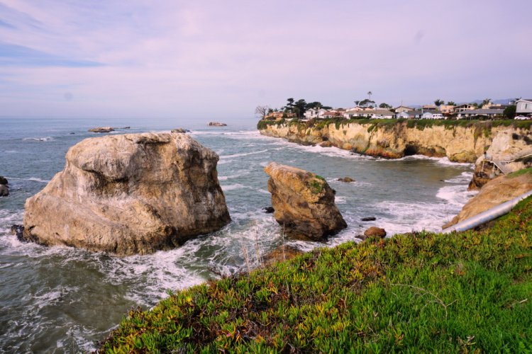
These parks are not necessarily known as hiking destinations but I have to include them in this list because they have some of the more breathtaking coastal scenes of San Luis Obispo County. This stretch of coast is full of promontories, coves, caves, arches, and wildlife (otters, sea lions, seals, and birds).
Start by parking your car at the Dinosaur Caves Park. From there, you can walk along different trails toward different viewpoints. The views are incredible. Get prepared to take tons of photos. The trails are suitable for all ages since they are short and flat. It is a great place to take kids (there is a playground) and pets.
Continue walking towards Margo Dodd Park (you are going to see the gazebo). From this point, you are going to see one of the more iconic views of the Central Coast. It is a joyous scene of rocks, arches, and colorful cliffs. You can get closer to the action by using the stairs located a few meters north.
You can walk as much as you want. I would say you can see a lot by walking a mile or less.


Hiking Trails Near Avila Beach: Nipomo
Of course, I have to add this cool hiking spot in Nipomo!
Oso Flaco Lake Trail
Distance from Pismo Beach: 13 miles
The Oso Flaco Lake 1.7-mile trail takes hikers through a diverse landscape of sand dunes, wetlands, and a freshwater lake.
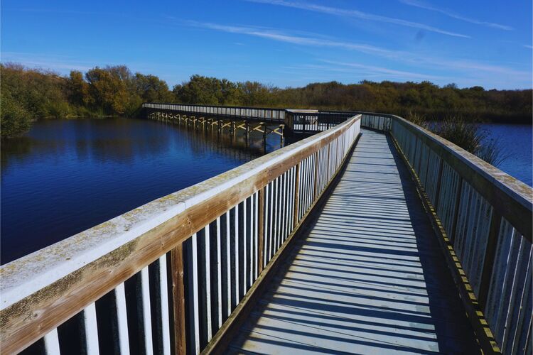
The trail begins at the Oso Flaco Lake parking lot, where you can pick up a trail map and get information about the trail conditions. The trail takes you through a shaded oak grove, boardwalk, vast expanse of sand dunes, and wetland area, where you can see a variety of bird species.
The trail then leads to Oso Flaco Lake, a freshwater lake that’s surrounded by tall grasses and cattails.
The Oso Flaco Lake Trail is an easy hike, suitable for hikers of all ages and abilities. The trail is flat and well-maintained, with plenty of benches and rest stops along the way.


More Hikes Near Avila Beach
We have covered a decent number of Avila Beach hiking trails. But, here are even more ideas around the Morro Bay and San Luis Obispo areas.
Montana de Oro State Park
Montana de Oro State Park is located just north of Pismo Beach and offers a variety of hiking trails. The park has over 8,000 acres of rugged coastline, canyons, and mountains. This is one of the most beautiful state parks in California. So make time to visit! You can thank me later.
The most popular trail in the park is the Bluff Trail, a 3 to 4 mile (depending on how far you walk) out-an-back trail that allows visitors to appreciate popular spots such as Spooner’s Cove and Corallina Cove.
The Valencia Peak Trail (another popular trail) is a 4.5-mile out-and-back trail that takes hikers to the top of Valencia Peak. The trail is considered moderate to difficult, but hikers are rewarded with stunning views of the coastline.
Johnson Ranch Open Space
Located in San Luis Obispo, the Johnson Ranch Open Space offers over 5 miles of trails that wind through grasslands, woodlands, and chaparral. The trails offer stunning views of the surrounding hills and are popular with hikers and mountain bikers.
Bishop Peak
Bishop Peak is a popular hiking destination located in San Luis Obispo. The peak is the highest in the Morros range and offers stunning views of the surrounding mountains and valleys. The trail to the top is just under four miles long and is considered moderate to difficult. The trail is well-maintained, and hikers are rewarded with breathtaking views at the top.
Irish Hills Natural Reserve
Located in San Luis Obispo, the Irish Hills Natural Reserve offers over 7 miles of hiking trails through rolling hills and oak woodlands. The trails are considered moderate in difficulty, and hikers are rewarded with stunning views of the surrounding landscape.


Preparation for Hiking in Avila Beach
Hiking in Avila Beach is a great way to explore the beautiful coastal scenery and get some exercise. However, before embarking on any hike, it’s important to be properly prepared. Here are some essential tips for preparing for a hike in Avila Beach:
Appropriate Footwear – Wearing proper footwear is crucial for a comfortable and safe hike. Opt for sturdy hiking boots or shoes with good traction and ankle support. Avoid flip flops or sandals, as they can lead to slips, trips, and falls.
Water and Snacks – It’s important to stay hydrated and fueled during a hike, especially in sunny and warm weather. Bring plenty of water and pack energy-boosting snacks, such as trail mix or protein bars.
Weather Considerations – Weather in Avila Beach can be unpredictable, so it’s important to check the forecast before heading out on a hike. Bring appropriate clothing layers, including a waterproof jacket, hat, and gloves. Avoid hiking during thunderstorms or other extreme weather conditions.
Trail Closures or Restrictions – Before heading out on a hike, it’s important to check for any trail closures or restrictions. Some trails may be closed due to seasonal maintenance or other safety concerns. Check local park websites or call ahead to ensure that the trail is open and safe to hike.


Avila Beach Hikes Gear
Consider taking the following on the Avila hiking trails:
- Wearing the right shoes is essential when hiking or walking. I recommend investing in a good pair. Merrell shoes have always been good for my crooked feet. My husband is more of a fan of the Salomon brand.
- I take the minimum with me when I go on trails. I keep everything organized in a small crossbody bag. My husband prefers to take a light day pack.
- Hiking poles are lifesavers on trails with an incline (more if you have wobbly knees).
- I protect myself from the sun with a wide bream hat, sunscreen, lip balm, and a long sleeve tee.
- Do not forget to bring water! We pack a cold beverage or hot coffee to enjoy after a hike. The THERMOS Tumblers keep drinks hot for 7 hours and cold for over 10 hours.
- I have never gotten used to taking pictures exclusively with my phone. I prefer to use the Sony Alpha a6000. It is compact and takes gorgeous pictures.
Other Outdoor Activities in Avila Beach
Avila Beach is not only a great destination for hiking, but it also offers a wide range of outdoor activities for visitors to enjoy. Here are some of the top outdoor activities to try in Avila Beach:
Kayaking – Kayaking is a great way to explore the stunning coastline of Avila Beach. Rent a kayak and paddle around the protected waters of Port San Luis Harbor, where you can spot marine life such as sea otters, dolphins, and whales. For a more adventurous experience, consider taking a guided kayaking tour to explore the sea caves and kelp forests around Avila Beach.
Surfing – With consistent waves and a mellow vibe, Avila Beach is a great spot for surfing. Whether you’re a beginner or an experienced surfer, there are plenty of surf shops and schools in the area that offer rentals and lessons. The waves at Avila Beach are generally smaller and less crowded than other nearby surf spots, making it a great place to practice your skills.
Fishing – Avila Beach is a popular destination for fishing enthusiasts, offering a variety of species such as rockfish, lingcod, and halibut. Rent a fishing boat or join a charter to head out into the Pacific Ocean for some deep-sea fishing. Alternatively, you can try your luck fishing from the pier or shore.
Biking – Rent a bike and explore the beautiful trails around Avila Beach. The Bob Jones City to Sea Trail is a popular biking route (discussed above).
Whale Watching – Take a boat tour to spot whales migrating along the coast of Avila Beach. Gray whales pass by during the winter and spring months, while humpback and blue whales can be seen during the summer and fall months. Keep an eye out for dolphins and sea lions as well!


Location
Avila Beach is located 88 miles from Santa Barbara, 183 miles from Los Angeles, and 241 miles from San Francisco.
By car, the city can be accessed through US-101.
The nearest airport is located in San Luis Obispo. There is an airport in Santa Barbara as well. Keep in mind these are small, regional airports. The closest Amtrak (train) station is located in Grover Beach.
Avila Beach is an ideal destination for those seeking an outdoor adventure. With its breathtaking scenery, abundant wildlife, and diverse range of activities, it’s no wonder that visitors keep coming back year after year. So, why not plan your next hiking trip or outdoor adventure in Avila Beach today?
More of Avila Beach
Avila Beach hiking trails are way too much fun! However, if you are interested in other activities, check out my detailed guide to things to do in the city and other cities in the county.
Shell Beach: Great Coastal Views
More of California
Los Angeles Ultimate Bucket List
Ultimate San Diego Bucket List
150+ Places to Go in Orange County
Places to Visit in Santa Barbara
Things to Do in Ventura County
Which of these Avila Beach hikes have you completed?


Leave a Reply