Want to discover the best Escondido hikes? Explore the city’s natural surrounding beauty in this complete hiking guide.
Nestled in the hills of San Diego’s North County, Escondido is a hidden treasure for outdoor enthusiasts seeking to explore the natural beauty of Southern California.
With its diverse landscape of rolling hills, canyons, and pristine lakes, the region boasts a range of stunning hiking trails, each offering a unique adventure and a chance to connect with nature.
From the serene beauty of tranquil lakes to the rugged terrain of mountain peaks, Escondido hikes cater to every type of hiker, from the casual stroller to the seasoned adventurer.
In this article, we’ll take a closer look at some of the best hiking trails in Escondido, highlighting their unique features, levels of difficulty, and why they are worth exploring.
So, whether you’re a local or just visiting, grab your hiking boots and get ready to discover the natural wonders that await you in Escondido.
Please note: This article contains affiliate links, meaning I may earn a commission if you make a purchase by clicking a link. Of course, this comes at no extra cost to you and helps me to keep offering solid information to readers.

Table of Contents
Best Escondido Hikes
Alright, before we get deep into the article, let me clarify the article highlights hiking trails near Escondido. Some hikes may fall within city limits while others fall in nearby cities or unincorporated communities.
The idea is to use Escondido as a base. I have done this many times and will do it again in a cinch. We love to hike and explore in the morning/afternoon and return to Escondido for dining, drinking, and shopping.
The trails discussed here are located 5 to 18 miles from the city center.
Now get ready to uncover the best Escondido hikes.


Elfin Forest Recreational Reserve
Distance from Escondido: 5 miles
The Elfin Forest Recreational Reserve is a 784-acre natural reserve located north of Escondido. The reserve offers a wide range of outdoor activities, including hiking (over 10 miles of trails), biking, and horseback riding, making it a popular destination for nature enthusiasts of all ages.
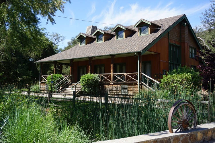
In addition to being a haven for outdoor activities, the reserve is home to an Interpretative Center, which offers a range of educational programs, exhibits, and a botanical garden. The center’s main goal is to educate visitors about the reserve’s natural history and the importance of conservation efforts in the area. Visitors can learn about the reserve’s ecosystems and the different species that call it home.
Note: The Interpretative Center is located close to the main parking area. No hiking is required to visit.
The reserve itself is home to a variety of animals, including bobcats, coyotes, and a wide range of bird species (so keep your eyes wide open). For birdwatchers, the reserve is a must-see destination, as it is home to over 150 different species of birds.
If you are visiting for the first time, I recommend hiking the scenic Way Up Trail, which takes hikers to the top of the hill (Harmony Grove Overlook) for breathtaking views of the surrounding area. Once at the top, you can walk a bit more to the Ridgetop Picnic Area to enjoy views of the Oliverhain Reservoir. The length of this trail is 2 to 3 miles depending on how far you make it. It is considered an easy route since there are plenty of switchbacks on the way up.
Fun Fact: There is another Elfin Forest in California! It is located in Los Osos (near Morro Bay), San Luis Obispo County


Del Dios Highlands County Preserve
Distance from Escondido: 3.5 miles
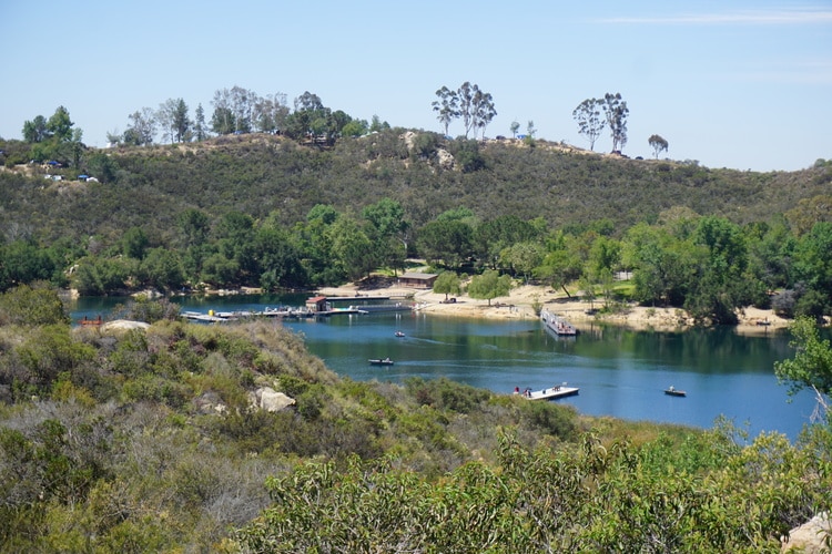
The Del Dios Highlands County Preserve is a 774-acre preserve that features an exercise trail and 1.5 miles of multi-use trails (hiking, biking, and horseback riding). The preserve is known for its stunning views of Lake Hodges, the San Dieguito River Valley, and the surrounding hills.
The main trail in the preserve connects to the trails in the Elfin Forest Recreational Reserve. If you decide to complete the trail, expect to walk a minimum of 2.6 miles (roundtrip). Again, the total hiking mileage will depend on how far you make it (it is tempting to keep walking around).
Now, get ready since this is a steep way up. The positive is that you will get incredible views of the Oliverhain Reservoir.


Daley Ranch
Distance from Escondido: 6 miles
Daley Ranch is one of Escondido’s most popular hiking destinations, offering 25 miles of gorgeous Escondido hiking trails that wind through the rolling hills and grassy meadows of this 3,150-acre nature preserve.
With its diverse landscapes of oak woodlands, chaparral, and riparian habitats, Daley Ranch is a haven for nature lovers and hikers seeking to explore the region’s rich flora and fauna (including deer, coyotes, and hawks).
The difficulty level of the trails varies, making them accessible to hikers of all skill levels. The trails are well-maintained, and there are plenty of picnic areas and restrooms along the way.
If you are visiting for the first time, I recommend walking a loop composed of the Ranch House, East Ridge, and Creek Crossing Trails. This easy 2.2 miles loop (perfect to do with kids) showcases the variety of the preserve.
Other Daley Ranch hiking trails include the Boulder Loop (moderate, 4 miles), Sage and East Ridge Loop (moderate, 5 miles), and Jack Creek Meadow (easy, 6 miles)
Note: A $5 donation is suggested. Consider donating to help keep the preserve pristine.


Dixon Lake
Distance from Escondido: 6 miles
Dixon Lake is a scenic reservoir located in the northeast of Escondido. The lake features a 1.5-mile hiking trail that loops around the lake and offers beautiful views of the surrounding hills and valleys. The trail is mostly flat and easy, perfect for families with children.
In addition to hiking, Dixon Lake is a popular destination for camping, fishing, and boating. The lake is stocked with a variety of fish, including trout, bass, and catfish, making it an excellent spot for fishing enthusiasts. The lake also features several picnic areas and a playground for children.
Note: Dixon Lake is located pretty much “across” Daley Ranch’s main entrance. If you are in the area, I recommend taking a look even if you do not attempt to hike around.


Lake Hodges
Distance from Escondido: 6 – 10 miles (depending on trailhead)
Lake Hodges is a beautiful reservoir located in the hills just south of Escondido. The lake features multiple trails offering gorgeous views of the surrounding hills and valleys.
Now, this is a vast lake. During my research, I was not able to get a definite answer on miles of trails in the area but some sources point to about 40 miles of trails. The positive is that trails are mostly flat and easy, catering to hikers of all skill levels.
The trails are accessible from several trailheads. One recommendation is to connect to the San Dieguito River Trail from the Bernardo Mountain Summit Trailhead. You will walk a bit next to the freeway before entering the lake area and getting views from the north shore.
It is about 3 miles (one way) to the first viewpoint and about an additional mile to make it to the Visitor’s Center.


Other options include parking on the northern part of the lake and walking to the Visitor’s Center (which can be extended to the viewpoint).
There is another parking area in the western part of the lake (look for Hernandez Hideaway). You can connect to all the points I have mentioned above from this trailhead. However, my opinion is that the views from the northern shore are better.
Experienced hikers may want to cover the 8.2 miles (16 miles round trip) of trail following the northern-western shoreline of Lake Hodges. This is a portion of the Coast to Crest Trail (some call this portion the Lake Hodges Trail). It goes from the Bernardo Mountain Summit Trailhead to the Lake Hodges Dam. Due to its length, this is an all-day affair.
Bernardo Mountain
Distance from Escondido: 6 miles
Bernardo Mountain is a popular hiking destination in Escondido, offering hikers stunning views of the surrounding mountains and valleys. The most popular trail to Bernardo Mountain starts at the Bernardo Mountain Summit Trailhead.
This is the same trailhead I discussed above. Instead of continuing to the lake viewpoint, hikes deviate to the top of the mountain.
This is a moderate 7.2-mile out-and-back trail featuring a steady climb to the top of the mountain, with a mix of rocky switchbacks and gentle slopes through coastal sage scrub and chaparral habitats. From the summit, hikers can enjoy panoramic views of the San Pasqual Valley, Lake Hodges, and the surrounding hills and mountains.


Piedras Pintadas
This is yet another trail located at the shores of Lake Hodges. Can you tell I love this area?
Piedras Pintadas is a unique and historic site. It’s one of the best hikes near Escondido and it takes hikers through a boulder-strewn landscape with amazing rock formations and ancient Kumeyaay Native American rock art.
The Kumeyaay people were the original inhabitants of the region, and their artwork can be seen in the form of petroglyphs (rock carvings) and pictographs (rock paintings) along the trail.
The Piedras Pintadas Trail is relatively easy and suitable for hikers of all skill levels. The course is 3.6 miles long and can be completed in about 1-2 hours. Hikers are advised to wear sturdy shoes and bring plenty of water, as the trail can be rocky and exposed to the sun.
Blue Sky Ecological Reserve
Distance from Escondido: 13 miles
Blue Sky Ecological Reserve is a 700-acre natural reserve located southeast of Escondido (in Poway). The reserve features over 13 miles of hiking trails, including the following:
- Green Valley Truck Trail to Creekside Trail and back – Easy, 1 mile
- Green Valley Truck Trail to Picnic Area – Easy, 2 miles
- Green Valley Truck Trail to Lake Ramona – Moderate, 3 miles
- Green Valley Truck Trail to the top of Mount Wilson – Difficult, 11 miles (you can connect to the Mount Woodson area, reach the Lake Poway viewpoint and go back)


Photo by Chris Palmer
Double Peak Park
Distance from Escondido: 10 miles
Double Peak Park is a 200-acre park located on a 1,600-foot peak that offers stunning panoramic views of the Pacific Ocean, San Marcos, and the surrounding mountains.
The park features over 4 miles of hiking trails, including the Summit Trail, which takes hikers to the peak for the best views.
The Summit Trail is a challenging hike with steep switchbacks and rocky terrain. The trail is approximately 4 miles round trip and takes about 2-3 hours to complete. Hikers should be prepared for a strenuous climb and bring plenty of water and snacks.
Stop by for great views even if you do not plan to hike. Also, you can drive to nearby Discovery Lake for great photo options.


Mount Woodson
Distance from Escondido: 13 miles
Located in the Poway area of San Diego County, the Mount Woodson Trail is a popular hiking destination that offers stunning views of the surrounding area. The trail is 7.5 miles long and is considered to be moderately difficult.
One of the reasons why the Mount Woodson Trail is so popular is the views from the summit, which includes the iconic Potato Chip Rock. The rock, which is a thin slice of granite that juts out from the mountain, has become a popular spot for hikers to take photos. Visitors can climb onto the rock and take photos that make it look like they’re standing on a potato chip. It’s a unique and memorable photo opportunity that draws visitors from all over the world.
In addition to the Potato Chip Rock, the summit of Mount Woodson offers stunning panoramic views of the San Diego area. Visitors can see everything from the ocean to downtown San Diego to the mountains in the east. It’s a great spot to take a break, snap some photos, and take in the natural beauty of the area.
The trailhead is easily accessible and there is ample parking. However, due to its popularity, the trail can get crowded, especially on weekends and holidays. Hikers are advised to arrive early to avoid crowds and to bring plenty of water and sunscreen, as the trail can be hot and exposed in some areas.


Escondido Hikes: Iron Mountain
Distance from Escondido: 18 miles
Located in the Poway area, the Iron Mountain Trail is 5.8 miles long and considered to be moderately difficult, making it a great spot for experienced hikers who are looking for a challenge.
Despite its difficulty, the Iron Mountain Trail is well-maintained and offers plenty of amenities for hikers. The trailhead has restrooms, water fountains, and picnic tables, making it a great spot for a pre-hike snack or a post-hike picnic. The trail is also well-marked and has plenty of shade, making it a great spot to hike even on hot days.
The summit offers panoramic views of the San Diego area, including views of the ocean, downtown San Diego, and even Mexico on a clear day. It’s a great spot to take a break, snap some photos, and enjoy the natural beauty of the area.
Escondido Location and Weather
Escondido is located in northern San Diego County. It is approximately 30 miles northeast of downtown San Diego and 100 miles south of Los Angeles. The city is situated in a valley surrounded by hills and mountains, providing a beautiful natural backdrop for residents and visitors.
Escondido is known for its mild climate, with warm, sunny summers and cool, rainy winters. The city experiences an average of 15 inches of rainfall per year and has an average temperature of 72 degrees Fahrenheit in the summer and 45 degrees Fahrenheit in the winter.


Safety Tips for Hikers
Preparation is key when hiking. Please take to heart the following advice.
Importance of Staying on the Trail
One of the most important things to keep in mind when hiking is to stay on the designated trail. Venturing off the trail can damage the park’s sensitive ecosystem and put you at risk of getting lost or injured. Additionally, staying on the trail helps to preserve the park for future generations of hikers and nature lovers.
Awareness of Wildlife
The Escondido hikes presented here are home to a diverse array of wildlife, including deer, squirrels, rabbits, and a variety of bird species. While these creatures are generally harmless, it’s important to be aware of your surroundings and give wildlife plenty of space. Hikers should never approach or feed wildlife, as this can cause harm to the animals and put you at risk.
Carrying Adequate Supplies
Before heading out on your hike, it’s important to carry adequate supplies to ensure your safety. This includes plenty of water, food, a first aid kit, and appropriate clothing and footwear. Additionally, it’s a good idea to carry a map of the park and a charged cell phone in case of an emergency.
Sun and Heat Protection
Winter, early spring, and late fall are the best times to hike in the park. Temperatures can get quite hot during the summer months. I do not recommend hiking if the temperature is over 100 degrees Fahrenheit. I would reconsider hiking even if the temperature is over 90.
Regardless of temperature, it is important to stay hydrated and protect yourself from the sun by wearing a hat, sunglasses, and applying sunscreen. Additionally, it’s a good idea to hike during the cooler parts of the day and take plenty of breaks in the shade.
Ask for help if you start feeling ill.


Escondido Hikes Gear
I recommend taking into consideration the following gear when planning your Escondido hikes:
- Wearing the right shoes is essential when hiking or walking. I recommend investing in a good pair. Merrell shoes have always been good for my crooked feet. My husband is more of a fan of the Salomon brand.
- I take the minimum with me when I go on trails. I keep everything organized in a small crossbody bag. My husband prefers to take a light day pack.
- Hiking poles are lifesavers on trails with an incline (more if you have wobbly knees).
- I protect myself from the sun with a wide bream hat, sunscreen, lip balm, and a long sleeve tee.
- Do not forget to bring water! We pack a cold beverage or hot coffee to enjoy after a hike. The THERMOS Tumblers keep drinks hot for 7 hours and cold for over 10 hours.
- I have never gotten used to taking pictures exclusively with my phone. I prefer to use the Sony Alpha a6000. It is compact and takes gorgeous pictures.


Whether you’re a seasoned hiker or just starting out, Escondido has hiking trails that are sure to meet your needs. So grab your hiking boots, pack some water and sunscreen, and head out to explore the natural beauty of Escondido’s hiking trails. You never know what wonders you might discover along the way.
More Hikes in Southern California
What Escondido hikes have you completed?


Leave a Reply